A huge storm is headed for the East coast—and it may end up being one of the heaviest we’ve seen in years. But it’s more than just the snowfall you have to watch out for; the storm is bringing absurdly powerful wind gusts and even flooding along with it.
Winter Storm Jonas (and a little further south, Winter Storm Ilias) are coming, and the National Weather Service describes the oncoming weather as both a “textbook” example of perfect winter storm conditions and “potentially crippling.” In Baltimore and Washington, DC, the NWS has warned that two feet of snowfall could accumulate between Friday, when the storm starts, and the end of Saturday.
For New York up through New Jersey, the forecast is much more uncertain, both in terms of whether we’ll be seeing snowfall, rain, or some unholy mix of the two, and as to just how much of each might fall. Even as far as North Carolina or Kentucky, there could be heavy amounts of ice piling up. Right now, the forecast calls for between 6-8 inches of some kind of unspecified wintry skywater in New York.
If NWS expectations for New York and the lower coastline seem vague in terms of expected snowfall, they are pretty precise about how windy things were going to get. Wind gusts at slightly below hurricane-force (50 mph) levels are likely to appear along the coast on Saturday.
Meanwhile, the NWS also pointed with a little nervousness at this weekend’s full moon. Why worry about a full moon in the middle of a snowstorm? Because of the high tides it brings with it; that paired with the high winds have the NWS warning that coastal flooding could be seen in multiple areas and with the waters already so high, it wouldn’t take much to see at least some flooding.
Sponsored
The closer the storm gets, the better the predictions become, so the forecast continues to fluctuate as we near the weekend.
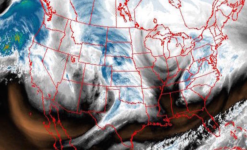
Top image: Water vapor map of the US over the last 24 hours, generated via NOAA’s mapping tool